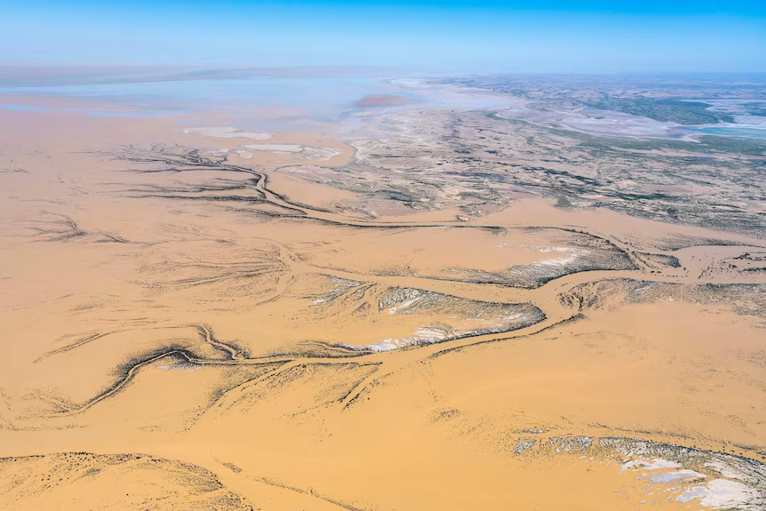


Kati Thanda-Lake Eyre in South Australia is on the verge of a dramatic transformation, as significant floodwaters from Queensland make their way south. Typically a vast salt flat in one of the country’s driest regions, the lake is expected to experience its most substantial water fill in at least 15 years.
This rare event follows heavy rainfall in Queensland’s Channel Country, which has begun flowing into the massive Kati Thanda-Lake Eyre Basin — the fourth-largest internal drainage system in the world. Spanning around 1.2 million square kilometres, the basin covers nearly a fifth of Australia’s landmass.
Despite the vast network of rivers and creeks that feed into it, the lake is usually dry. Located around 750 kilometres north of Adelaide, it sits in an arid zone with the lowest annual rainfall in Australia — just 150mm per year. Intense heat and high evaporation rates mean water rarely stays long, even when it arrives.
Most water is lost en route, either soaked into floodplains or evaporated before reaching the lake. Only in exceptional flood years does the lake fill significantly. Since 1900, this has happened only three times, with the last full filling recorded in 1974 during Australia’s wettest year on record.
This year, however, conditions are aligning for another major fill. Recent rainfall has already created a shallow pool at the lake’s southern end. Meanwhile, major floodwaters are slowly pushing their way across Queensland’s outback plains, moving at a crawl through the flat terrain.
Two major waterways are driving the inflow: the Diamantina River, which becomes the Warburton River in South Australia, and Cooper Creek. The Diamantina’s flood peak is currently near Birdsville, and it will eventually flow into Lake Eyre via the Warburton. Cooper Creek, known for its sporadic contributions, is also running high, with water levels not seen in decades.
This time, Cooper Creek’s impact is expected to be greater than usual. It had already been flowing since early summer, meaning the system was primed for additional runoff. Satellite imagery shows the flood peak near the South Australian border, indicating weeks of sustained flow still to come.
The Bureau of Meteorology predicts the lake will begin filling in May, with peak inflows likely between late June and early July. While it’s difficult to estimate the maximum depth due to the lake’s complexity and variable factors, current upstream data suggests it could surpass the levels seen in 2019 — and possibly rival the 2010 flood.
Increased local rainfall in South Australia has also pre-saturated the landscape, making it easier for water to reach the lake without being absorbed en route. Waterholes have already begun to fill, setting the stage for a smoother and more efficient flow southward.
If no further major rainfall events occur, the lake is expected to reach its fullest extent during winter before slowly receding through spring. However, some deeper sections may retain water into the summer months, offering a rare and breathtaking glimpse of Australia’s largest lake in bloom.